Dettifoss & Mývatn
Shortly before 10 am I drove into the parking lot at information center in Reykjahlíð by the lake Mývatn. I had a 10 am appointment with a couple of Catalan friends who were also driving the Icelandic Ring Road. We had planned to go together on a tour of the north-east.
Our first stop was to visit a trio of waterfalls in the Jökulsárgljúfur canyon — Dettifoss, Selfoss and Hafragilsfoss. We decided to approach the waterfalls from the east, having referred with several people who knew the area. We had heard mixed stories of which of the roads was better, the western or the eastern, but there was a consensus that the view was better from the east bank of the river Jökulsá á Fjöllum.
The road to the falls was indeed rather bumpy, a typical Icelandic “washboard road”, a gravel road with a series of parallel ridges perpendicular to the driving direction. It was a bit like driving in a massage chair. The harmony of the corrugations was broken up from time to time with a seemingly random distribution of potholes.
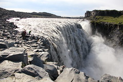
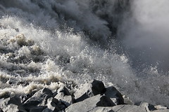
We started our waterfall exploration at Dettifoss, the most powerful waterfall in Europe. Before arriving at the fall, I was wondering if it would be an underwhelming experience compared to my visit to the Iquazú Falls last november. It wasn’t. The power of the waterfall was spectacular and the area was stunningly beautiful. The main difference between visiting Dettifoss and Iguazú Falls is that at Dettifoss you experience nature while at the Iguazú Falls the sensation is more that of an amusement park.
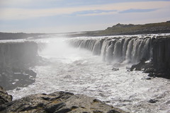
Having admired Dettifoss from a distance as well as up close, we hiked upstream along the canyon to the Selfoss waterfall. Although less powerful than Dettifoss, Selfoss was, to me, more beautiful. It is much wider than Dettifoss, yet impressive as it falls off the cliff into the canyon.
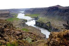
The final waterfall we visited in Jökulsá was Hafragilsfoss, a short drive downstream from Dettifoss. While somewhat similar to Dettifoss the surrounding gave us a different view since it is visible from a hill above the canyon.
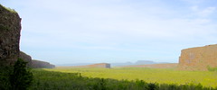
After a picnic by Hafraglisfoss we continued our journey to Ásbyrgi — a horseshoe shaped canyon north of Dettifoss. Legend has it that the canyon is formed by catastrophic glacial flooding of the river Jökulsá á Fjöllum. A more probable explanation is however that it was formed when Óðin’s eight-legged horse, Sleipnir, hit one of its feet on the ground. The huldfólk (hidden people) who live in the surrounding cliffs informed us that the former explanation comes from an ancient Icelandic belief in mysterious creatures called geophysicists.
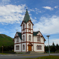
From Ásbyrgi we headed west to Húsavík — a typical Icelandic village with a church, swimming pool and a harbor. We did not visit the swimming pool but took brief glimpse at the church and the harbor. However, since the day was running late we only stopped for a few moments in town before continuing our trip back to lake Mývatn.
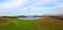
Arriving at the lake we found it wrapped in haze. Given that the wind was blowing rather strongly from the south, I suspect the haze to have been combined with ash from the Grímsvötn eruption of 2011.
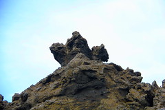
We started our Mývatn exploration by having a stroll between Skútustaðagígar, a series of pseudocraters formed by explosive gasses that form when hot lava flows over water. We then made our way to Dimmuborgir, a dark city of oddly shaped lava. With a bit of imagination we walked among the castles of the elves and hudufólk, dragons, monsters and other strange creatures.
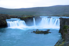
After a nice day in the north-east we drove to Akureyri with a stop at Laugar where we had a typical Icelandic lamb soup, kjötsúpa. For dessert we took a look at yet another sweet waterfall, Goðafoss, a significantly less powerful waterfall than Dettifoss, but beautiful all the same.