Roca Centella
When I lived in Reykjavík and Amsterdam I would often regret spending a sunny day indoors. I would say to myself that this should never happen again. I should use the few chances I got to use the sunny days for outdoor activities. After moving to Barcelona, things have changed. During the summer months the feeling is quite the opposite. Sunny days are usually too warm for outdoor activities (I do not consider sitting outside in the shadow and drinking beer as an outdoor activity). If I spend a cloudy day indoors I regret not having spent it on the move.
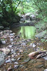
Green reflection in Riereta river
Last Sunday promised to be a cloudy day according to the weather forecast. Hence, I used the chance to go for a hike in the Montseny Natural Park together with a couple of friends. We set off from Figaró and headed for La Garriga along the PR C-33 short distance path. The plan was to follow the PR C-33 path — more or less — with a mid-way detour to the top of Roca Centella (1001m).
The first part of the hike was along the Riereta river north of Figaró. About 15 minutes into the hike the cloudy day threatened to become less cloudy. The clouds fell from the sky. It started raining. Fortunately we were in a forested area and could seek shelter under the trees. For the next 20 minutes or so the rain varied in intensity from “not quite raining at all” to “raining quite a bit”. Thus we marched from tree to tree in order to make use of the dry periods for advancing and having a shelter for the rainy periods. Fortunately the rain did not last long and we could continue with our hiking plans.
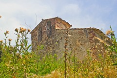
The church of Sant Cristòfel de Monteugues.
The path was easy to navigate until we reached the church of Sant Cristòfol de Monteugues. At that point we left the marked route and headed toward Roca Centella along an old gravel road. Our first milestone was to get to a tree called Alzina de Can Valls which was marked as a major landmark on the map. According to the map we could get there by following a road which was in a bad condition.
Shortly before arriving at Can Valls we saw on our left something that could possibly be defined as a road in bad condition — but could also be defined as some sort of a narrow field with wheel marks. In the hills above us we could also see several instances of something that could possibly be the landmark tree — at least they could be called trees (well … to an Icelandic person, anything that is green and higher than one meter can be called a tree). Anyway … we started our way along that something that could possibly be defined as a road in bad condition towards that something that could possibly be called the landmark tree.
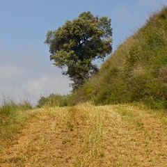
A road in bad condition or wheel marks through fields … a tree or the tree
The road — assuming it was a road — was not trivial to follow since there were many side roads that could also possibly lead us to the tree. Furthermore, we soon came to a dead-end. We backtracked and chose a side road. We came to another dead-end. We backtracked. We chose another side road. We came to another dead-end. We backtracked again and chose another side road leading to yet another dead-end. On our walk we passed quite a few trees — and quite decent trees — but none of them was remarkable enough to be marked as a landmark on the map.
After a few dead ends we started to suspect that we were maybe not on the road that we had hoped to be on. However, since we were gradually going in the direction where the landmark tree was supposed to be, we decided to continue our dead-end exploration in the hope that we would eventually stumble upon the right road that would lead us to the right tree.
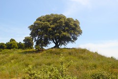
Alzina de Can Valls
A few minutes and a few dead-ends later we stumbled upon something that we considered more likely to be a road in bad condition than the wheel marks we had been following so-far. We were relieved. The road did indeed turn out to be the road we were looking for and it lead us to the landmark tree we were looking for. Alzina de Can Valls turned out to quite some tree and far more remarkable than the trees we had passed on our way. Not the least for the sake that we now knew that we were on the right road.
The road from from Alzina de Can Valls to Roca Centella was non trivial. Again and again we arrived at crossroads where we had to consult out maps and compasses in order to decide which road to take. Nevertheless, we managed to reach our destination without ever taking a wrong road. This was a tremendous milestone towards boosting the confidence in our cartography skills.
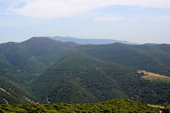
The view from Roca Centella.
Before heading back down to Sant Cristòfol de Monteugues and onwards to La Garriga, we ate our lunch at the top of Roca Centella and enjoyed the view towards Tagamanent and over the Montseny Natural Park.
The path down provided few navigational challenges. Our main challenge was to survive the heat. The day turned out not to be as cloudy as we had hoped. Fortunately, we were properly equipped with water and were able to get to La Garriga without any difficulty. Behind us was a nice six hour hike in the Montseny Natural Park.